Extraction in Ghana.
Lead researcher
In January of 2016, the journal Extractive Industries and Society accepted my masters thesis as an original research article: Evaluating conflict surrounding mineral extraction in Ghana: Assessing the spatial interactions of large and small-scale mining.
The work examines the spatial interactions of small and large-scale miners in south-central Ghana. A random forest classifier was used to identify small-scale mining in Landsat imagery, and these areas were then compared to the locations of large-scale mining concessions.
Below are are the abstract and figures from the paper.
Since implementation of its Economic Recovery Program in 1983, Ghana’s extractive industries have come to account for 40% of the total value of the country’s exports. An adverse impact of this increase, however, has been increased extraction-related conflict due to heightened competition between large and small-scale operators over mineral-rich ands. This paper characterizes these conflicts in the south-central section of the country by mapping the spatial overlaps between large and small-scale miners. Classification tree analysis of 2013 and 2015 Landsat- 7 and -8 imagery was used to identify small-scale mine sites. The overlaps between these sites and large-scale concessions are examined in the context of reported mining conflicts. Results reveal that there is a large amount of resource competition between the two parties, specifically, more than half (i.e., 52%) of the identified small-scale mining activity occurs within the boundaries of large-scale concessions. The northwest corner of the study area contains 50% of the identified overlaps; the southwest corner contains 40%; and the northeast corner contains 10%. In most cases, these overlaps take place on prospecting concessions. The work illustrates how mapping and quantifying areas of spatial overlap between large and small-scale miners can help stakeholders implement more effective policy solutions.

Figure 1: Study area is shown along with large-scale mines, regional borders, rivers, and the major geological formations running throughout the area.

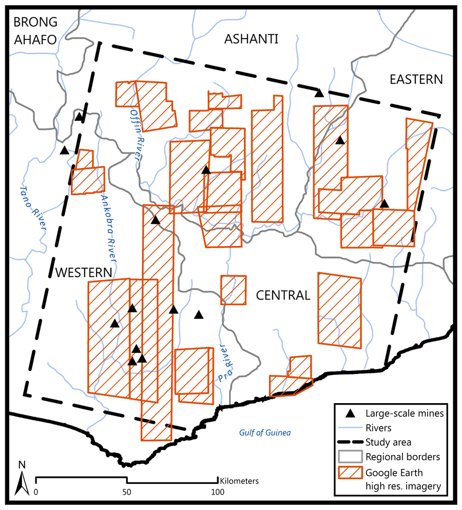
Figure 2: Locations of high spatial resolution imagery from GeoEye-1, WorldView-1, and WorldView-2 used to perform map accuracy assessment on the small-scale mining maps (Landsat-7 and -8 images).

Figure 3: Map of small-scale mining (SSM) activity derived from the classification of the Landsat-7 and -8 2013 and 2015 imagery in the context of large-scale concessions, large-scale mines, unofficial small-scale mining concessions, and unsuitable small-scale mining areas.

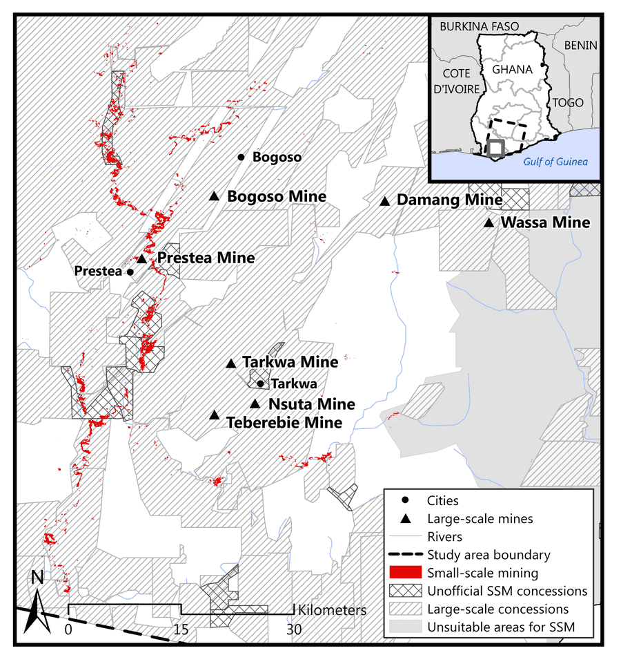
Figure 4: Northwest region of the study area shown with the small-scale mining (SSM) derived from the 2013 and 2015 Landsat-7 and –-8 imagery in the context of the surrounding cities, large-scale mines, large-scale mining concessions, unofficial small-scale mining concessions, and unsuitable small-scale mining areas.

Figure 5: Southwest region of the study area shown with the small-scale mining (SSM) derived from the 2013 and 2015 Landsat-7 and -8 imagery in the context of the surrounding cities, large-scale mines, large-scale mining concessions, unofficial small-scale mining concessions, and unsuitable small-scale mining areas.

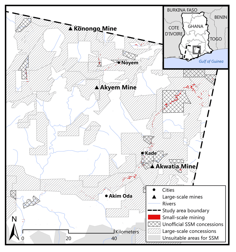
Figure 6: Northeast region of the study area shown with the small-scale mining (SSM) derived from the 2013 and 2015 Landsat-7 and -8 imagery in the context of the surrounding cities, large-scale mines, large-scale mining concessions, unofficial small-scale mining concessions, and unsuitable small-scale mining areas.